| Arkansas Watersheds >> About | Home |
|
||
|
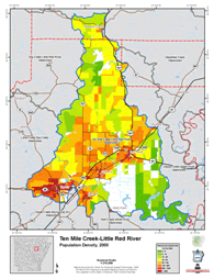
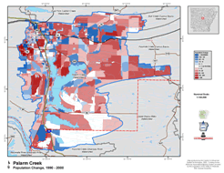
About - The Arkansas Automated Reporting and Mapping System (AARMS), funded by the Arkansas 85th General Assembly through the Arkansas Natural Resource Commission, will help provide citizens and decision makers with easily accessible information via the internet. The Arkansas Watershed Information System is a comprehensive statewide electronic watershed atlas consisting of a series of practical maps and reports for the 308 watershed units across the state. Accurate watershed information is required by federal, state and local agencies. The Arkansas Watershed Information System will provide ready access to information and high quality maps to assist local communities in their responses to federal requirements and to improve decision making.The 308 ten-digit watershed units and the 1556 twelve-digit sub-watersheds were delineated for the entire state by the Natural Resources Conservation Service. The Arkansas Watershed Information System provides more than 3,696 thematic maps and 17,700 summary reports in an accessible and easy to use format. PLEASE NOTE:
Maps and reports in the system include:
|
Funded by the Arkansas 85th General Assembly through the Arkansas
Natural Resources Commission
Center for Advanced Spatial Technologies Copyright 2006